2022 Washington State Scenic Calendar

The images have been selected and the printing has begun: The 2022 Washington State Scenic Calendar are here.

Twelve images from across the state, complete with 3 rainbows and a lighthouse! 

Printed on a 100lb bond glossy sheet, each sheet is 8″ x 12″. No cropping and no borders! Calendars are ring bound and shrink wrapped!

Calendars are now available locally in Mount Vernon at Re-Feather Your Nest and also at the Skagit Food Co-op

Cost is $25, plus $7.00 shipping/handling. Order your calendar online here.

HERE is the link to Order your copy of the Washington State Scenic Calendar!

Photography and Photoshop Classes

Starting in February 2021 I will be teaching a Basic DSLR Photography Course AND a 5-session Photoshop Class, online, through Bellingham Parks and Rec.

The Basic DSLR Photography Class is for beginners. We will cover how to shoot in the manual mode, learn about bracketing and how to get the right shot, and also cover use of a circular polarizer, RAW files, and more. You need to have a DSLR Camera for the class. The class is scheduled for two different days (same Class, both days). Thursday, Feb 18, from 6 to 8pm. and again on Tuesday, March 11, from 6pm to 8pm. You can enroll online here, through Bellingham Parks and Rec. The class is $50.

Intro to Photoshop is a 5-session series of classes for anyone interested in learning some basics of Photoshop. We will spend 2 lessons learning how to edit your landscape, nature and outdoors images with Adobe Camera Raw. This is a fun and fast way to edit your images. We will also do several assignments together, both capturing images and then editing them with Photoshop. We will cover Multiplicity, Levitation and Panorama.

To take the Photoshop Class you must have a current subscription to Adobe Photoshop/Creative Cloud.

Each class is $50, or you can enroll for all 5 classes for $200. Here is the link to Bellingham Parks and Rec to enroll. Classes are Wednesday Nights, Feb. 17, Feb 24, March 3, March 10 and March 17, all classes from 6 to 8pm, all online.

Cape Disappointment

Cape Disappointment is located at the southwestern corner of Washington State, at the mouth of the Columbia River. There are two lighthouses, wonderful beaches and great camping in Cape Disappointment State Park.

The general area is known as the Graveyard of the Pacific due to the number of shipwrecks over the years. More than 100 days of fog each year! The Coast Guard has an active base at the Cape.

The nearest town is the Port of Ilwaco, with a nice marina and a few hotels. Oceanside is 10 miles to the north, a true Beach Resort Tourist Mecca…

The Cape is at the base of a long peninsula stretching north for almost 30 miles. In many places there is beach access with your car: you can tool up and down long beautiful stretches of sand… Highway 103 extends to Leadbetter State Park, at the northern tip of the peninsula.

Not far from the South Lighthouse is small Waikiki Beach. Here are some day time and night time images from there:

The beacon of the South Lighthouse is visible, as well as the line of ships leaving the bay with the high tide. The two bright stars, to the left of the Milky Way are Saturn and Jupiter…

The North Lighthouse is easily accessible and quite beautiful…


The Port of Ilwaco is the nearest town, with a nice marina and a few hotels.

The Palouse

The Palouse is a section of SE Washington state where they grow a lot of wheat. The terrain is smooth rolling hills and almost all of it is covered with endless green.

The Palouse is the most popular spot in Washington for Photography Tours. There are endless viewpoints and all sorts of photo opportunities over there.

I found a map that shows where all the cool stuff is. Its like a treasure hunt! 

Barns, old farm equipment, abandoned houses and vistas are marked, but its still tricky finding some of the stuff…

Most people drive up atop Steptoe Butte for images, like the one above.

But there are wonderful vistas all over, and exploring is a blast.

The wheat is about a foot tall now, (late May) and will stay green as it grows a while, then late summer it all turns golden brown…

Then I will need to go back for another visit.

Here are a few more pics from 2 days of rambling…


North Cascades Photography – Cap Sante Park

North Cascades Photography – Cap Sante Park

Finding a great vista is like finding gold to a photographer. A view point from which to capture sunrises, sunsets, moon or stars is priceless. There are many in the North Cascades: Washington Pass Overlook along Highway 20 and Artist Point, at the end of the Mt Baker Highway are two fantastic spots. Down in Skagit Valley one of my favorites is located in Anacortes, along the Cascade Loop Highway.

Anacortes is located on Fidalgo Island. Rosario Strait and the San Juan Islands are to the West while to the South, Deception Pass separates Fidalgo and Whidbey Islands. To the East, the Swinomish Channel separates Fidalgo Island from the mainland.

Cap Sante Park is a 37 acre forested promontory at the eastern edge of Anacortes. It is primarily a viewpoint overlooking the marina, the City of Anacortes, March Point, Fidalgo Bay and the Cascades. A remnant of an amphitheater is located on the east bank of the park.

There is plenty of parking, no rest rooms, and a few very short trails.

Sunrise here is especially spectacular. The serrated ridge-line of the North Cascades scrapes the horizon and Mount Baker grandly stands guard over the proceedings.

This particular set of images of from a sunrise a few weeks ago…

Nearby is Cap Sante Marina. Make sure to stop by for some more wonderful images of all the boats…

Here are a few more images from recent sunrise visits to Cap Sante.


Winchester Lookout, Star Trails and the Aurora Borealis

Summer is coming! That means Night Sky Photo Tour opportunities along the North Cascades Highway! If you’re interested in learning how to capture images of the Milky Way, here is a recent article “Astrophotography with a DSLR” to help get you started.

North Cascades Photography – La Conner Daffodil Festival

North Cascades Photography – La Conner Daffodil Festival

The La Connner Daffodil Festival signals the start of spring in the Skagit Valley.

As the dreary winter drags to a close the fields of the Skagit Flats slowly come alive. This years winter was a bit longer than we’re used to, snow was covering the ground only a few weeks ago.

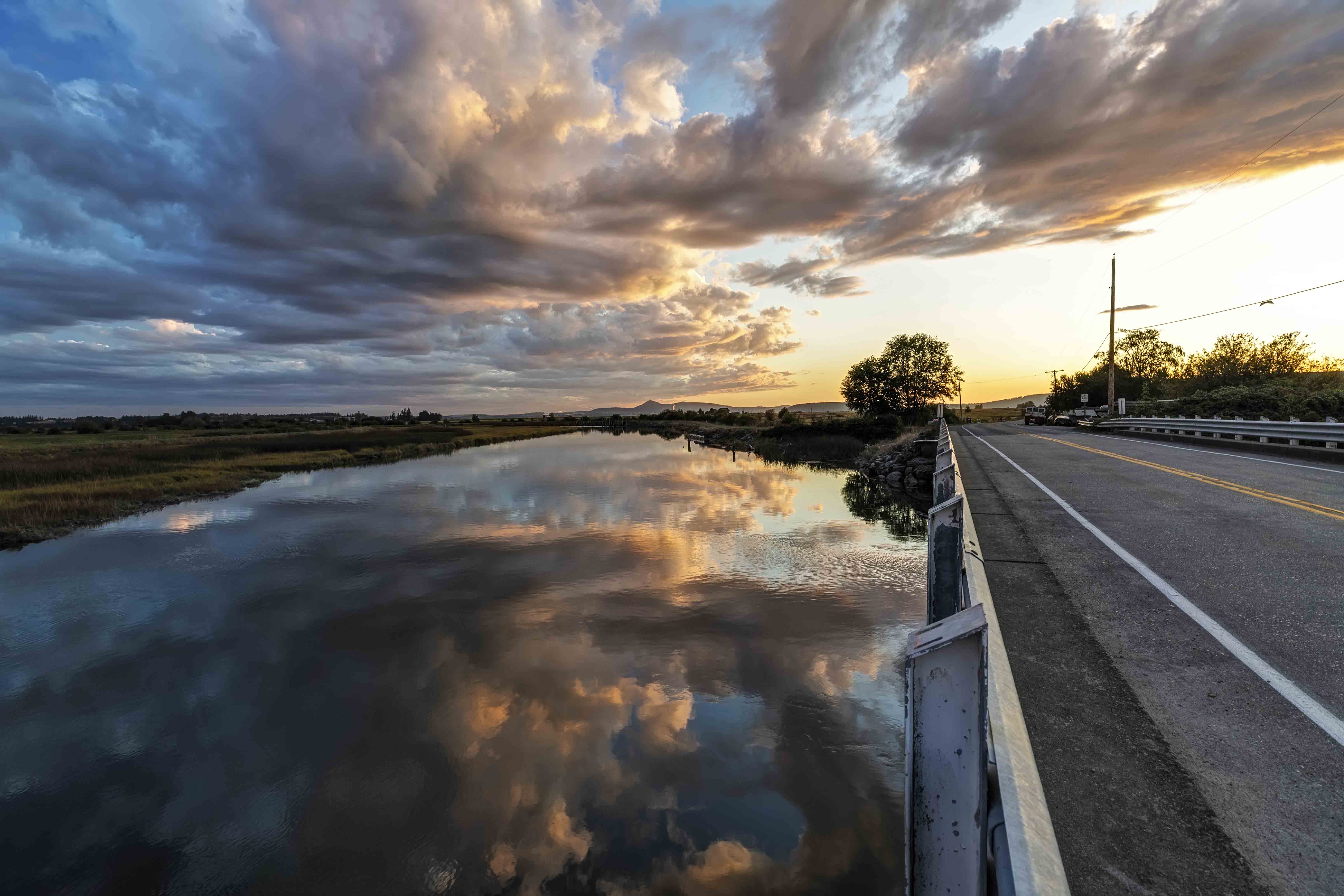
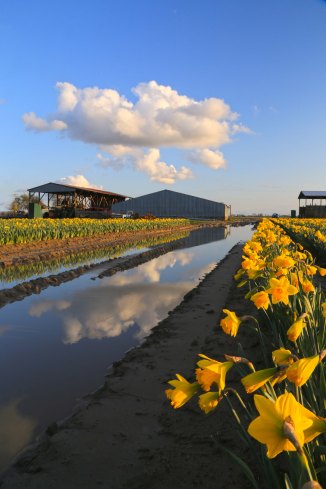
Several warm, sunny spring days is all it took to start this years bloom. Here is a recent image, “Daffodils Under the Moonlight” from March 22, along the La Conner Whitney Road.

Daffodils Under the Moonlight

The bright colors is all it takes to chase away any lingering winter blues!

Each year the daffodils are in different locations, the Bloom Map shows where the fields are located, and when they are in bloom.

Spring is a wonderful time to hit the highway and drive along the Cascade Loop. Skagit Valley is one of many destinations calling you…

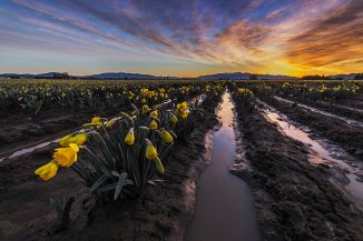
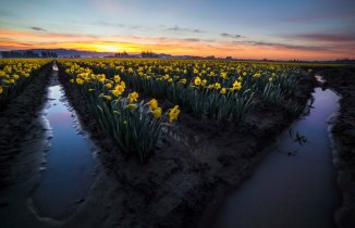
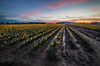
Here are a few images from earlier years…
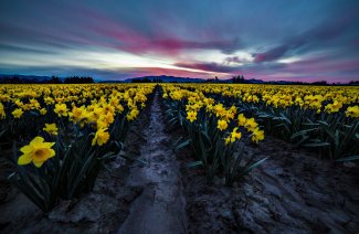
The La Conner Daffodil Festival starts whenever the daffodils start to bloom, which can be anywhere from late Feb until late March.

There is a Photo Contest as well:

La Conner Daffodil Festival Photo Contest

Photographers get ready for the La Conner Daffodil Festival Photo Contest!  All you have to do to be entered to win is take your photos during the La Conner Daffodil Festival and then post to Facebook or Instagram with hashtag #laconnerdaffodils.  We will then choose the top 10 photos and have the public vote on the winning photograph!  The winner will receive a cash prize and be crowned the La Conner Daffodil Festival Official Photo. The photograph will also be used for publicity for the following La Conner Daffodil Festival!

The best times are sunrise and sunset. Please don’t park your car anywhere you’re not supposed to, and be careful out there!

Here are a few more images from years past.

If you’re interested in a sunrise or sunset Photo Tour of the Tulips or Daffodils, I lead Photo Tours Week nights for sunset and weekends for sunrise. here is the link to sign up! Skagit Tulip Festival Photo Tours

Night Sky Imaging at Beacon Rock, Jan. 2019

Beacon Rock State Park is located along the Columbia River, on the Washington side. Its not far from the Bridge of the Gods and Cascade Locks.

I visited once and walked to the top. Its quite something. I have no idea what its like, photographically; which seasons, times and conditions are best. But the next New Moon is Jan 5th, 2019.

My plan is to shoot night sky images at Beacon Rock State Park on Jan 4th and 5th.

The good thing about shooting night sky in January is that its dark early; you don’t have to stay up to 1am to see anything. Its as dark as its going to get by 8 or 9pm, latest.

I am offering Night Sky Photo Tours to anyone who wants to make the drive down there. The cost is $150 per person. Payment is due day of the tour, prepayment or deposits are not needed.

Details about Night Sky Photo Tours here.

If you’re interested in Beacon Rock Jan 4th and/or 5th, 2019, email me at andyporterphotography@gmail.com and I can answer any questions.

Night Sky Images at Winchester Lookout

The Winchester Mountain Fire Lookout is located in the Mount Baker-Snoqualmie National Forest, along the Mount Baker Highway. This is one of the few remaining lookouts in Washington. Most of them were removed, but several are now maintained by local alpine clubs. The Mt Baker Club does a fantastic job of caring for and maintaining the Winchester lookout, you can donate to their efforts here.

During the summer the lookout is open to the public, you can day hike up and spend the day there, or if you’re inclined, you can spend the night. There are no reservations, its first come, you got it for the night. If you hike up and the lookout of already claimed for the night there is plenty of flat space nearby where you can pitch a tent.

I have hiked up and spent the night atop Winchester Mountain 5 times, three of those trips I slept in the lookout, and 2 times I camped in my tent. Basically, if you want to sleep in the lookout, go on the weekdays and go very early. And bring a tent or a bivvy sack just in case! Oh yes, and bring all your water, there is none there, nor along the hike.

The view from the lookout is unbelievable.

As you can imagine the night sky views are fantastic. To the south and east the darkness is almost complete. The western horizon is aglow in the direction of Vancouver to the north, Bellingham to the west and Skagit Valley south.

These 4 images were taken during the same evening. Check out the green aurora glow!

During the same night, a view of Mount Larrabee from Winchester.

Here is one more for good measure. Good luck and happy shooting! I may see yo there.

If you’re interested, Night Sky Photo Tours are available, you can find out more here. 

Silesia Camp and Copper Ridge, North Cascades National Park

The North Cascades National Park turns 50 this year! Learn more about its history here.

This is the 4th post in a series highlighting spectacular places in the North Cascades National Park. You can access earlier posts here.

Silesia Camp is located along Copper Ridge in the northern section of the North Cascades National Park.

You can hike there in one day, access is from the Hannegan Pass trail head. You must have a permit to camp there. Details here.

There are few camp sites with a better view then Silesia Camp.