Vistas of Skagit Valley

Skagit valley stretches a long way from Ross Lake to Anacortes. Along the way there are many promontory spots from which to view its magnificence!

Diablo Lake is a emerald jewel at the foot of Colonial Peak.

Sauk Mountain rises more than 5,000 feet above the valley

Samish Overlook affords spectacular views of the valley.

Mount Erie and Cap Sante in Anacortes are wonderful vistas.

2021 Washington State Scenic Calendars are now on sale! Here is the link to see the images and order your copy!

An evenings walk near Conway

There is a boat ramp and you can walk atop the dike, along Dike Road, near Conway.

The South Fork of the Skagit River is nearby.

Several of the farms nearby have wonderful old barns…

Here are a few images.

Skagit River Images

The Skagit River plays a very big role in life here in the valley. Transportation; electricity; salmon; irrigation; and more are centered around the river.

The early days of white settlers along the Skagit River are chronicled here quite well, in the Skagit River Journal.

Traveling along and across the river affords some good opportunities to capture images, from time to time. These are some recent images, some over the last few years of journeys.

Fir Island Sunrise

Its always good to start any day with a colorful sunrise. Some nice clouds, water for reflections, a wide panoramic view…maybe some mountains off in the distance all make the scene perfect.

These images are from two very recent visits to Fir Island sunrise.

Sunday, November 24

Thursday, November 28

The broad expanse of sky, over the ocean and mouth of the Skagit River. There are several vista spots alone Fir Island Road, most require a Discover Pass.

2020 Night Sky Calendars are available here.

Interested in a Photo Tour? Tulip Photo Tours in April are now filling up fast. 

Night Sky Photo Tours are my favorite! More info here. 

Skagit River and Mount Baker

Not long ago I saw an image of Skagit River with Mt Baker looming above. It was a gorgeous image and started me on a hunt.

I have been here in Skagit Valley for 15 years now and have never encountered a vista that encompassed both the Mountain and the River. Skagit River runs east to west through the valley and Baker sits about 10 miles to the north.

A short study of the map revealed that there are several spots where the Skagit turns back on itself so that you can look “down the river” and right at Mt Baker. I started my search along the Concrete Sauk Valley Road, looking to visit the confluence of the Sauk and Skagit Rivers. It was a lot of fun tooling about, on both sides of the river, scouting for views, vistas, and access trails down to the gravel bars along the river.

Here are a few pics from my endeavors:

After a bit of search I finally found a spot along the Concrete-Sauk Valley Road where you can scramble down to the gravel bar and out to this view: Looking north to Mt Baker, from the Skagit River


Autumn in Skagit Valley and North Cascades

One doesn’t normally associate the northwestern corner of the US with fall colors. New England the Mid-Atlantic states in the northeast are usually the focus of any autumn photo spread.

But autumn in Skagit Valley and North Cascades is not too shabby.

The valley and the rivers make wonderful spots for fall.

Up the valley a bit along the Baker and Skagit Rivers fall colors abound. Salmon spawn in the fall. The entire valley is lit up and on display!

The 2020 Washington State Night Sky Calendar is now on sale! Get your copy here.

The main contributors to Fall here in the North Cascades are the blueberry/huckleberry bushes, which carpet the mountains in bright reds and the larch, who’s green needles turn bright orange in the first week or October. . .

North Cascades Photo Tours are also available!

Larch grow new green needles each spring, and in early October they turn orange and fall off! The elevation of the larch varies in Western Washington, usually you can find the larch between 5,000 and 7,000 ft elevation.

Fine Art Prints as well as Canvas Wraps are also available in a wide range of sizes and frames. Here is the Gallery Page.

Vistas of Skagit Valley

Always in the hunt for new vistas of Skagit Valley, here are some of the vistas I’ve visited in the last few years.

North Cascades Photography – Skagit Valley Tulips

North Cascades Photography – Skagit Valley Tulips

Skagit Valley Tulips

The start of spring in Skagit Valley heralds the Skagit Valley Tulip Festival.

Broad swaths of brightly colored tulips spring up all over the flats.

This is one stop along the Cascade Loop that you don’t want to miss!

Photographing them is wonderful fun. The saturation of colors, the often cloudy skies and lots of mud always make the trip an experience.

The Washington Bulb Company is the leading grower of tulip, daffodil, and iris bulbs in North America. They grow bulbs throughout the valley and have a huge display garden, Roozengaarde. There is a store, a windmill and manicured beds of flowers, and in the back, large fields of tulips.

You can read about the history of tulips in Western Washington and Tulip Festival here.

Always stick to sunrise and sunsets, and avoid the “Tulip Area” at all costs between 10am and 6pm on weekends and your experience will be a pleasant one!

Each year the location of the fields change, and so do the backdrops. Barns are sometimes nearby the fields, as well as buses, trees and other cool stuff.  You can see where the tulips are, and when they bloom through the Bloom Map.

Once you have scouted out where the fields are for the new season you can get a good idea of whats best for each location. Some will be better shot at sunset and others at sunrise.

Parking is always an issue. Sometimes the large fields have a parking area nearby and collect fees for visiting. Sometimes the fields are located near no parking at all. Be prepared to walk a while.

I visit the fields often, they are close by. The skies in Skagit Valley can get crazy late in the afternoon. Often the worst, rainiest days are best: the dark, heavy clouds sometimes give way to magnificent sunsets.

Photo Tours are available, I take tours on weekdays, for sunset and on weekends for sunrise. Here is the link.

Here are a few images from Tulip Festivals Past!


North Cascades Photography – La Conner Daffodil Festival

North Cascades Photography – La Conner Daffodil Festival

The La Connner Daffodil Festival signals the start of spring in the Skagit Valley.

As the dreary winter drags to a close the fields of the Skagit Flats slowly come alive. This years winter was a bit longer than we’re used to, snow was covering the ground only a few weeks ago.

Several warm, sunny spring days is all it took to start this years bloom. Here is a recent image, “Daffodils Under the Moonlight” from March 22, along the La Conner Whitney Road.

Daffodils Under the Moonlight

The bright colors is all it takes to chase away any lingering winter blues!

Each year the daffodils are in different locations, the Bloom Map shows where the fields are located, and when they are in bloom.

Spring is a wonderful time to hit the highway and drive along the Cascade Loop. Skagit Valley is one of many destinations calling you…

Here are a few images from earlier years…

The La Conner Daffodil Festival starts whenever the daffodils start to bloom, which can be anywhere from late Feb until late March.

There is a Photo Contest as well:

La Conner Daffodil Festival Photo Contest

Photographers get ready for the La Conner Daffodil Festival Photo Contest!  All you have to do to be entered to win is take your photos during the La Conner Daffodil Festival and then post to Facebook or Instagram with hashtag #laconnerdaffodils.  We will then choose the top 10 photos and have the public vote on the winning photograph!  The winner will receive a cash prize and be crowned the La Conner Daffodil Festival Official Photo. The photograph will also be used for publicity for the following La Conner Daffodil Festival!

The best times are sunrise and sunset. Please don’t park your car anywhere you’re not supposed to, and be careful out there!

Here are a few more images from years past.

If you’re interested in a sunrise or sunset Photo Tour of the Tulips or Daffodils, I lead Photo Tours Week nights for sunset and weekends for sunrise. here is the link to sign up! Skagit Tulip Festival Photo Tours

North Cascades Photography – Skagit Valley Sunrise

North Cascades Photography – Skagit Valley Sunrise

Photographing sunrise requires a bit of luck. You have to decide where to be for the sunrise, and so you go, in the dark, hoping for nice light…

Once you’re there and the sunrise starts, its usually too late to change locations. Today was one of those exceptions!

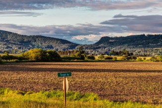
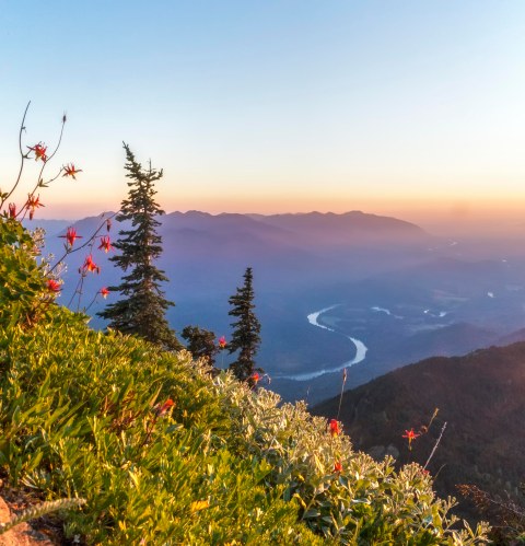
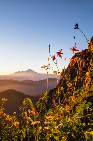
There are many wonderful vantage points along the Cascade Loop Scenic Highway from which to photograph the Skagit Valley. One of my favorites is Sauk Mountain. The Skagit River loops in broad curves to the west…

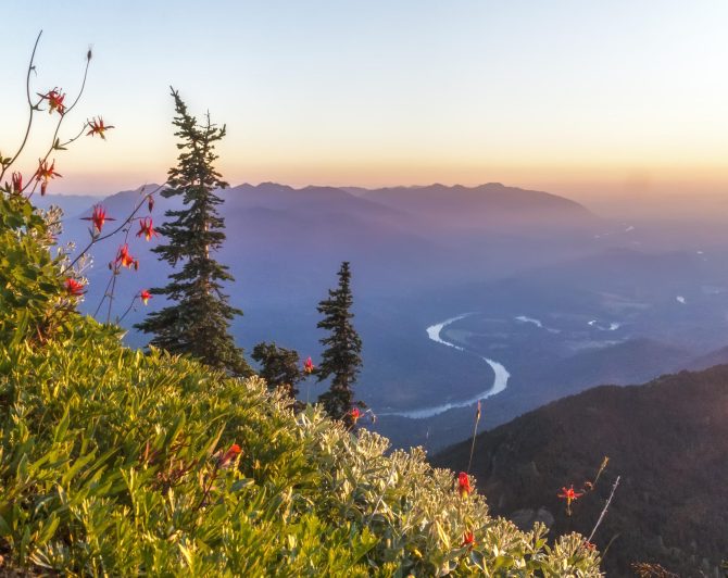
Skagit Valley from Sauk Mountain

But this is only a hike for the summer months, access to the trail usually begins in late May.  Depending upon the years snow fall the wildflowers start blooming in June. Its quite a sight. Here is the link with directions.

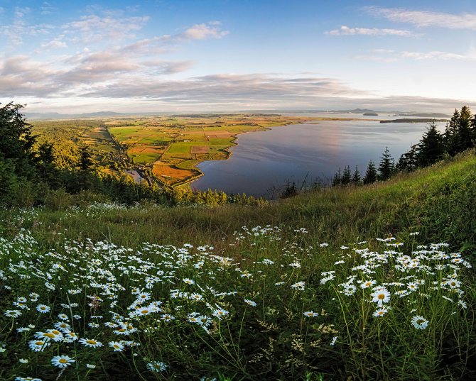
For year round access the view from the Samish Overlook is not to be beat. The overlook is located near the Alger exit on I-5. You need a Discover Pass. There are rest rooms at the Overlook and a trailhead leading to Oyster Dome and other places.

Here are directions to the Samish Overlook:

Directions: Samish Overlook    Lake Samish Rd     Bow, WA 98232
From I-5 exit 240, Alger. Go northwest on Samish Lake Road for .5 miles. Turn left on Barrel Springs Road for .7 of a mile. Turn right on B-1000 Road signed Blanchard Forest Block. Go 1.5 miles to intersection with the B2000, signed for Samish Overlook. Turn left and drive 2.1 slow miles to the Samish Overlook and the trailhead.

Skagit Valley

This morning I got an early start and headed to the Samish Overlook, but the road was closed. At Barrell Springs Road there was a barricade…so no luck.

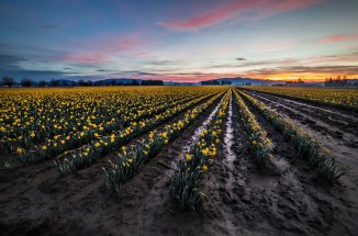
Sunrise over Samish River, March 17, 2019

It looked like it might actually turn out to be a nice sunrise, so I headed to my 3rd go-to place for sunrise, The Samish River.   Here is the image from this morning. I swear the clouds were trying to spell out something for me. I will work on decoding the message later.

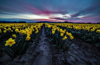
Here is a pano from the same spot.

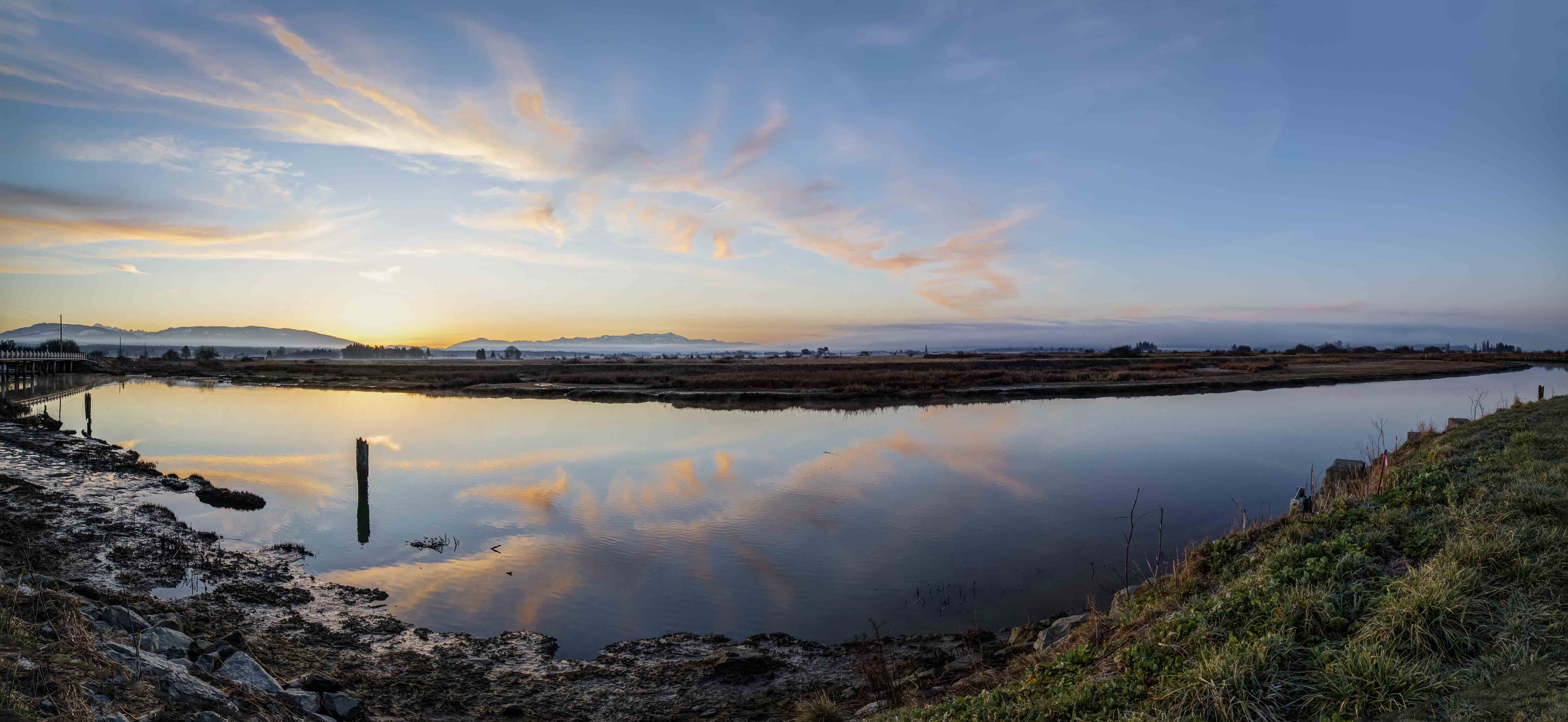
Sunrise Panorama over Samish River, March 17, 2019

If you can read the message (maybe its in Italian!) please send me a translation!

Photo Tours!

  • Tulip Photo Tours will start soon, these are 3 hour sunrise or sunset tours through the tulip fields.
  • Summer brings North Cascades Photo Tours, day hikes and overnight hikes to awesome places in the North Cascades.

These next images of the Samish River were taken from a bridge along the Bayview-Edison Road.

Here are some images from past visits, from the bridge facing the mouth of the river.

If you go to visit the Samish River be sure to stop by the Bread Farm, in Edison, and bring lots of cash.